The ground feels solid because, on human timescales, it usually is. Yet the rocks beneath us are continually being pushed, pulled and sheared. An earthquake happens when part of that stressed rock system suddenly slips, sending vibrations outward. Understanding the sequence—from slow loading to fault rupture to shaking—helps explain why nearby places can experience the same earthquake very differently. It also separates what scientists can measure well from what they cannot yet predict, and shows why a magnitude number alone never tells the whole story.
Key takeaways
- Earthquakes release stored elastic strain when rocks suddenly slip along a fault; the rupture can spread beyond its starting point.
- Magnitude describes an earthquake’s overall size. Intensity describes its effects at a particular location.
- Different seismic waves arrive and move the ground differently, while local geology and buildings shape the resulting shaking.
- Aftershocks are expected after many earthquakes, but their exact timing and size cannot be reliably predicted.
How a locked fault stores energy
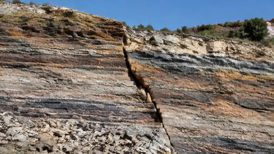
Earth’s outer rocky shell is divided into moving tectonic plates. Their movement changes stresses in the crust, especially near plate boundaries. Rocks can deform elastically: they change shape under stress while retaining the capacity to spring back. A fault is a fracture, or zone of fractures, along which rocks have moved relative to one another.
Friction and irregular surfaces can keep part of a fault locked even while the surrounding crust continues deforming. Stress builds until resistance is overcome. The fault then slips abruptly, and some stored elastic strain energy becomes seismic waves. Other energy goes into processes such as frictional heating and breaking rock.
Why “springing back” is only part of the story
Elastic rebound describes the release of deformation around the fault, not a return of everything to its previous position. Slip leaves permanent displacement across the fault. The earthquake is therefore both a brief vibration-producing event and a lasting rearrangement of rock.
Where rupture begins—and where it travels
The hypocenter, also called the focus, is where an earthquake rupture starts underground. The epicenter is the point on Earth’s surface directly above it. These are useful reference points, but a substantial earthquake is not simply an explosion at a single dot.
Rupture spreads across an area of fault as neighboring patches slip. Its direction, depth and extent influence how energy reaches different places. A location away from the epicenter may still be close to another part of the ruptured fault. That is one reason epicentral distance alone cannot fully explain shaking.
Boundaries are busy, not exclusive
Many earthquakes occur where plates collide, separate or slide past each other. Others happen within plates, where stresses can reactivate older faults. Being far from a plate boundary does not mean earthquake risk disappears. Fault geometry also varies: rocks may slide sideways, move upward relative to one another, or drop downward, depending on the stress pattern.
How seismic waves carry the disturbance
A fault rupture sets the surrounding rock in motion. Seismic waves transfer that disturbance outward; the rock does not travel all the way from the fault to a distant city. Instead, material moves locally as the wave passes, transferring energy onward.
P waves, or primary waves, are compressional. Material alternately compresses and expands along the direction of travel. They are the fastest seismic waves, so they generally arrive first at a recording station.
S waves, or secondary waves, involve shear motion: material moves perpendicular to the direction the wave travels. They are slower than P waves and cannot propagate through liquids as shear waves.
Surface waves travel along Earth’s surface. Their motion can include rolling or side-to-side movement, and they can contribute strongly to damaging shaking.
The medium matters
Wave behavior depends on the material involved. That broad principle also appears in why the sky is blue, although light scattering in air and mechanical vibrations in rock are different physical processes. Seismic waves change speed and direction as they cross materials with different properties.
Why magnitude is not the shaking you feel
Magnitude is an estimate of an earthquake’s overall size, derived from seismic recordings and, depending on the scale, information about the source. An earthquake has one overall magnitude estimate at a given stage of analysis, although agencies may revise it as better data become available.
Intensity is local. It describes the strength and effects of shaking at a particular place, using observations or instrumental estimates. The same earthquake can produce many intensities across a region.
A one-unit increase in magnitude corresponds to roughly ten times the recorded wave amplitude under comparable, appropriately corrected measurement conditions. It also represents roughly 32 times the energy release. These are scale relationships, not promises that every location will shake ten times harder. Magnitude scales differ in how they are calculated, and local motion depends on more than source size.
An illustrative comparison
For a hypothetical magnitude 6 earthquake and a hypothetical magnitude 5 earthquake, the approximate energy ratio is 32 to one. That does not establish the damage ratio: depth, distance, geology and construction still matter.
Why neighboring places can shake differently
Waves generally lose strength as their energy spreads and materials absorb it. But their route is not uniform. Rock layers, sediment-filled basins and near-surface ground conditions can alter the amplitude, frequency and duration of motion.
Soft sediments may amplify some kinds of shaking compared with nearby firm rock. Basins can prolong motion by trapping and redirecting wave energy. Buildings respond differently too: their height, stiffness, structural system and condition influence which motions affect them most strongly. Neither “soft ground” nor “tall building” is a complete damage forecast.
Read an earthquake report in layers
Illustrative example: imagine two towns at similar distances from a rupture. One sits on firm rock; the other occupies a sediment-filled basin. Their reported intensities may differ despite sharing the same earthquake magnitude.
When reading a report, compare the magnitude with the depth, mapped shaking and local observations. Check whether a map shows measured or modeled shaking rather than assuming every colored area represents identical evidence. A single personal account cannot describe the whole affected region.
What happens after the first strong jolt
A large rupture changes stresses in surrounding rock. Subsequent earthquakes in the affected region are called aftershocks when they belong to that sequence. Their rate generally decreases with time, but the sequence need not fade smoothly, and a later earthquake can still be damaging.
A foreshock is identified retrospectively: an earlier earthquake receives that label after a larger related event follows. A small earthquake is not automatically a warning that a large one is coming.
Scientists can estimate earthquake probabilities and forecast aftershock activity, but cannot reliably predict an earthquake’s exact time, location and magnitude. Earthquake weather and unusual animal behavior do not provide dependable exact predictions. Research into how plants communicate with each other concerns biological signaling, not evidence that organisms can forecast fault rupture.
Earthquake early warning is different from prediction. It detects an earthquake already underway and may send an alert before stronger shaking reaches a more distant location. It cannot guarantee advance notice everywhere.
Frequently asked questions
Is the epicenter always the worst-hit place?
No. The epicenter marks the surface point above the rupture’s starting location, not necessarily the center of strongest shaking. Rupture can extend along a fault, and local sediments, wave direction and building vulnerability affect consequences. Areas farther from the epicenter may therefore experience stronger shaking or greater damage than places closer to it.
Does every offshore earthquake cause a tsunami?
No. A tsunami requires substantial displacement of water, often associated with sudden movement of the seafloor. An earthquake’s location, depth, size and fault movement all matter. An offshore epicenter alone is insufficient evidence. For coastal decisions, follow official tsunami information and local evacuation guidance rather than judging the threat from magnitude alone.
Can small earthquakes prevent a large earthquake?
Not reliably. Small earthquakes release energy, but a one-unit magnitude increase represents roughly 32 times more energy. Modest events therefore do not simply “use up” a fault’s capacity for a larger rupture. They also change nearby stresses, sometimes promoting additional slip. A quiet period or a cluster of small events does not establish safety.
Why do magnitude estimates change after an earthquake?
Initial estimates use the recordings available quickly, which may not fully capture the earthquake’s size or rupture characteristics. Additional stations and analysis can improve the estimate. Different methods may also produce somewhat different results. A revision usually reflects better measurement and interpretation, not a change in the earthquake that has already occurred.
From a fault to your location
An earthquake begins with slipping rock, but its local effects emerge from the entire path between rupture and observer. Keep the source, traveling waves and receiving ground separate in your thinking. That distinction makes earthquake maps, magnitude updates and reports of uneven damage much easier to interpret.
Sources and further reading

Written by
FactNest Editorial Team
FactNest is operated by Muonix. The FactNest Editorial Team publishes general-interest explainers with AI-assisted drafting and illustrations. Contact contact@muonix.co for questions or corrections; we respond within 2 business days.
More from this author →